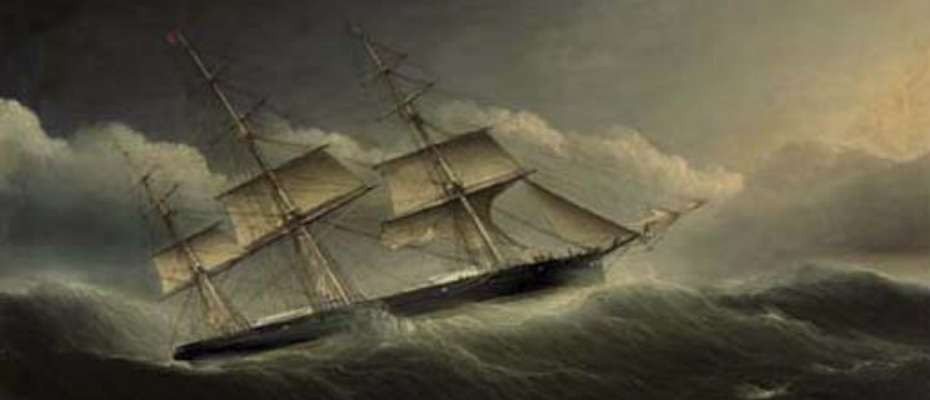
a clipper in a hurricane
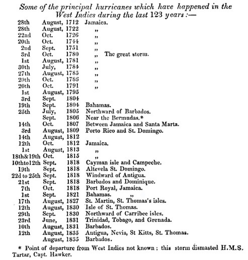
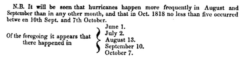
In the 19th century accounts of hurricanes became more widely available, and scientific knowledge of their nature more accurate; the development of the electric telegraph from the 1830s onwards began to make advance warning of coming storms increasingly possible. Jamaica began to become a centre for meteorological information.

|
|
19th century [21 recorded]
- 1803 August between Jamaica and U.K.
- 1804 two Hurricanes: 29 August[?]; 22 September
- 1810 15 August[?]
- 1812 15-16 August - off south coast
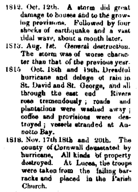
- 1812 12-14 October Hurricane
- 1813 31 July -1 August
- 1815 17-19 October Hurricane
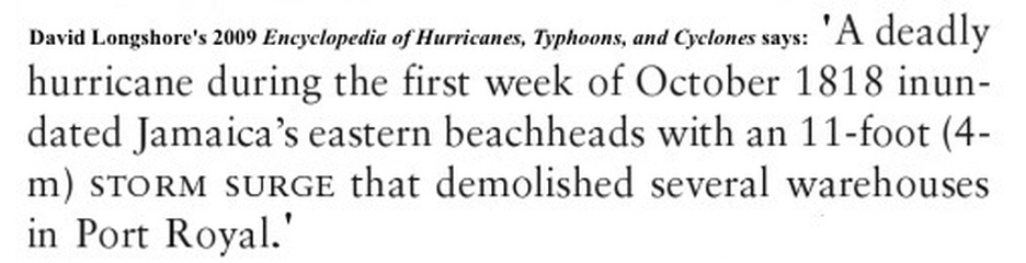
- 1818 October Hurricane[?]
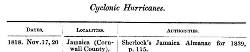
- 1818 17-20 November Hurricane [? 8-12 November]
- 1830 7 August Hurricane
- 1832 7 August Hurricane[?]
- 1841 Nancy Prince: refers to hurricane conditions in June[?]
- 1844 5 October Hurricane Western Parishes
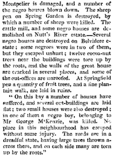
- 1852 6-8 November[?]“The late stormy weather has done considerable
damage in many parts of this side of the island, where the land has a south eastern exposure, particularly to plantain-walks and cornfields; but the wind having remained steadily in the south-east point, the principal part of the shipping, as well as the plantain-walks and cornfields on the north side have experienced but little injury.” (Jamaica Royal Gazette 1852). - 1874 November Hurricane
- 1879 8 October Hurricane
- 1880 18-19 August Hurricane, damaged Kingston
- 1884 6-8 October
- 1886 28-9 June
- 19-20 August
- 1899 28-9 October hurricane
- 7-8 November storm
The Nautical Magazine: A Journal of Papers on Subjects Connected with Maritime Affairs, Volume 6, 1837
|
|
|
hurricanes of the early 19th century as listed in a Gleaner editorial, September 1, 1880:
1804 & 1810
While many lists include one or both of these years as recording one or more hurricanes/storms in Jamaica, I am having little success in finding any details.
1812
A Chronological Table of Cyclonic Hurricanes which have occurred in the West Indies and in the North Atlantic from 1493 to 1855; with a bibliographical list of authorities. Andrés Poey
date location reference[s]
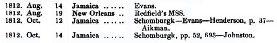
August 14-16
'Nearly 200 years before Hurricane Katrina, a major storm hit the coast of Louisiana just west of New Orleans. Because the War of 1812 was simultaneously raging, the hurricane's strength, direction and other historically significant details were quickly forgotten or never recorded.
But a University of South Carolina geographer has reconstructed the storm, using maritime records, and has uncovered new information about its intensity, how it was formed and the track it took.'
Science Daily, February 6, 2011
But a University of South Carolina geographer has reconstructed the storm, using maritime records, and has uncovered new information about its intensity, how it was formed and the track it took.'
Science Daily, February 6, 2011
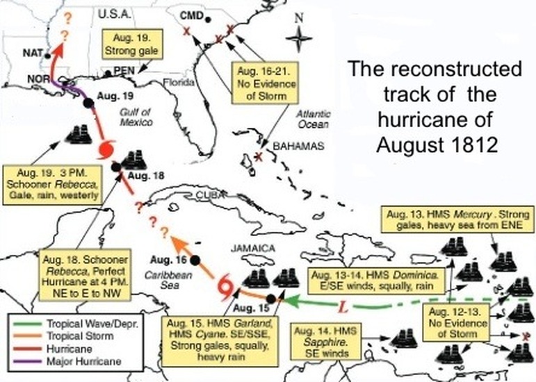
from 'THE GREAT LOUISIANA HURRICANE OF AUGUST 1812'
by Cary J. Mock, Michael Chenoweth, Isabel Altamirano, Matthew D. Rodgers, and Ricardo García-Herrera
'Several British logbooks and newspapers reveal the cyclone as developing toward tropical storm strength on its approach to Jamaica by late on 15 August and likely continuing to strengthen early into 16 August (Chenoweth 2003). The HMS Garland, south of Jamaica, reported persistent southeast winds, squally weather, and strong gales, which are indicative of tropical storm strength, although there is still not yet definite evidence of a closed circulation. The HMS Cyane, sailing near the Black River south of western Jamaica, experienced mostly east-southeast winds late on 15 August, with strong gales and heavy rain, and these continued through midday into 16 August as it approached eastern Jamaica.'
|
“The late stormy weather has done considerable damage in many parts of this side of the island, where the land has a south eastern exposure, particularly to plantain-walks and cornfields; but the wind having remained steadily in the south-east point, the principal part of the shipping, as well as the plantain-walks and cornfields on the north side have experienced but little injury.”
Jamaica Royal Gazette, August 22, 1812. |
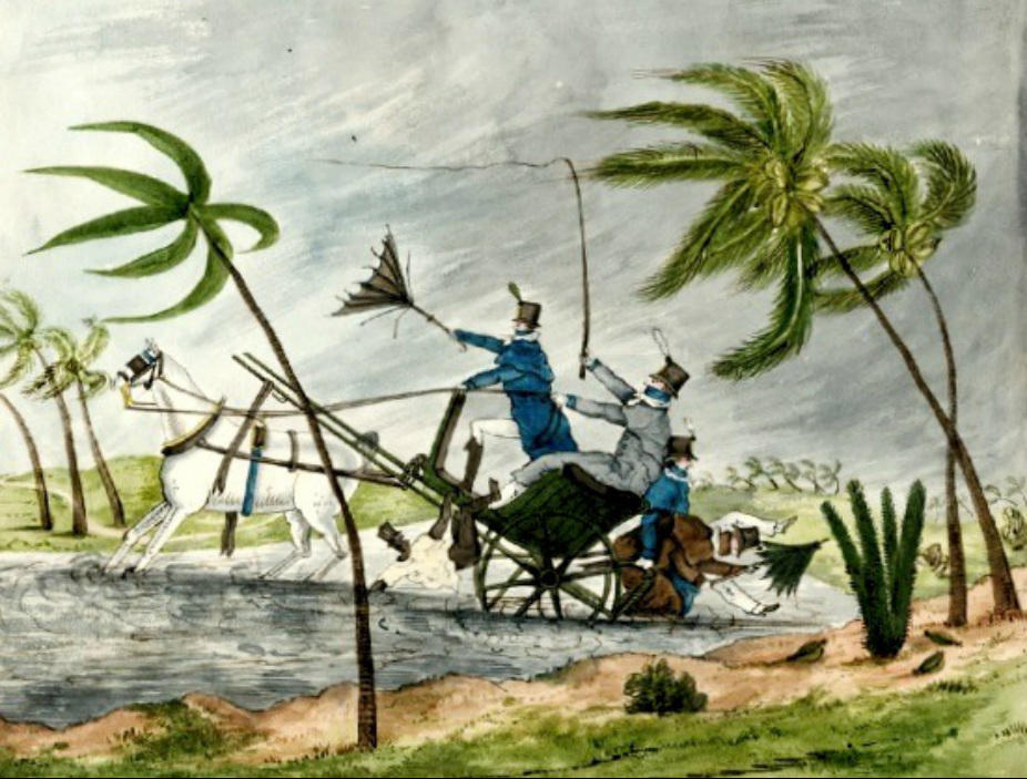
A watercolour of a scene in a hurricane, it seems, painted in Jamaica in 1812, by Catherine Street, about whom nothing is recorded.
(Brown University Library)
[This watercolor is from an album of original drawings and watercolors done by an English lady by the name of Catherine Street, about whom further information is unavailable. The album also includes military scenes, a view of the battle of Waterloo, and pictures of Britain and Europe, painted in the early years of the 19th century and published in 1821. World Digital Library.]
October 12-14
1812
Oct. 12th. A hurricane swept the whole Island; it was a very large cyclone; by a cyclone is meant a storm more or less severe which the wind rotates around the centre of low barometric pressure while the centre advances on its course. All the storms and hurricanes in the West Indies are cyclones; and in general, when we write of a "storm" or "hurricane" we wish to call attention to the loss of life or the damage done to property, and when we write of a "cyclone" we wish to call attention to the natural laws regulating the sweeping of the winds round the centre of low barometric pressure. In the present instance we have have no barometric readings, but the direction and changes of the wind at Kingston, Morant Bay and Montego Bay, and the notes as to what occurred at Lucea and Savanna-la-Mar assure us that the storm was caused by a large cyclone which passed over the Island from Old Harbour to the Dolphin Head.
On the 12th the sea was heard roaring all day, and as night came on the rain fell in torrents, and the wind blew hard from the S.E. In Kingston many outhouses and fences were blown down and great damage was done to the wharves and shipping. At Port Royal some houses were demolished, and 27 schooners, sloops and smaller boats were destroyed. At Spanish Town but little damage was done. At Salt Hill in the Parish of Port Royal, a piece of land of about 16 acres with a small house on it sank down and moved 300 or 400 yards from its original situation without injuring the house.
At Morant Bay the wind blew hard from the South at 1 a.m. on the 13th, and veered to the West; there was but one vessel in the Bay which was thrown to a considerable distance on the land. The lake at Rio Hoe in St. Ann's rose considerably with the heavy rains. At Lucea it blew a perfect hurricane about midnight, and a few vessels in port were driven ashore; at 9 a.m. on the 13th the wind suddenly ceased. At Montego Bay the storm commenced from the North, the wind veered to the South-East, and reached its greatest strength at 7 a.m. on the 13th. At Savanna-la-Mar the sea was driven up the main street as far as the Court House, and several houses were blown down. - (Jamaica Mag.)
from Maxwell Hall: Notes of Hurricanes and Earthquakes (1926)
In 1813 the sugar crop fell off 8,000 hhds. compared with the previous year, and we are told in reference to this circumstance, that there was a storm in October 1812. This remark is evidently made to account for the decrease, and perhaps the storm at the close of the previous year was the cause of it. But it is astonishing, and the circumstance is worthy of notice, that whilst the sugar crop fell off nearly 8,000 hhds. the coffee crop increased nearly six millions of pounds. We should have supposed that the coffee trees would have suffered more from the effects of a storm, than the canes. However, the effect was as we have stated it, whatever might have been the cause.
Emancipation in the West Indies: A six months' tour in Antigua, Barbadoes, and Jamaica in the year 1837, James Armstrong Thome, Joseph Horace Kimball, American Anti-Slavery Society, published by the American Anti-Slavery Society, 1838
Emancipation in the West Indies: A six months' tour in Antigua, Barbadoes, and Jamaica in the year 1837, James Armstrong Thome, Joseph Horace Kimball, American Anti-Slavery Society, published by the American Anti-Slavery Society, 1838
A storm, later in the year, [October 12, 1812] did great damage to houses, and destroyed immense quantities of growing provisions, a calamity more serious on account of the war with the United States preventing importations from that quarter.
A History of Jamaica from Its Discovery by Christopher Columbus to the Present Time,
William James Gardner, 1873
A History of Jamaica from Its Discovery by Christopher Columbus to the Present Time,
William James Gardner, 1873
In October 1812 a severe storm occurred, which destroyed the growing food of the people, and threatened a famine.
Jamaica: Its History, Constitution, and Topographical Description : with Geological and Meteorological Notes, McCartney & Wood, 1884
Jamaica: Its History, Constitution, and Topographical Description : with Geological and Meteorological Notes, McCartney & Wood, 1884
A "tremendous storm" struck the island in October 1812. The agricultural reporter for The Jamaica Magazine [1812-13] commented that the effects were less serious than feared, particularly "with respect to the plantain-walks, which yield their bread-fruit in a continued succession."
Jamaican Food: History, Biology, Culture, B. W. Higman - 2008
Jamaican Food: History, Biology, Culture, B. W. Higman - 2008
|
|
|
1813
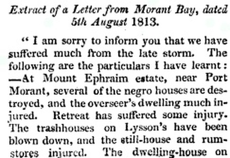
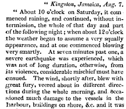
Jamaica. - August 7. - By the hurricane which visited us some days ago, between 20 and 30 schooners and small vessels were either sunk, driven ashore, or otherwise materially injured in our harbour.
In the harbour of Port Royal, there were several small vessels lost. The damage done to the house and plantations in various parts of the island has been very considerable. The plantain walks have particularly suffered.
In the harbour of Port Royal, there were several small vessels lost. The damage done to the house and plantations in various parts of the island has been very considerable. The plantain walks have particularly suffered.
The Literary Panorama, Vol. 14, Charles Taylor, 1813
|

The Scots Magazine and Edinburgh Literary Miscellany, Volume 75, Part 2
Archibald Constable & Company, 1813 |
|
|
|
1815 > > >
Jamaica: Oct. 18, 1815 - A most tremendous hurricane by which the whole island was deluged, many vessels wrecked, many houses washed away, and many seamen and white people drowned, with some hundreds of negroes.
The Tablet of Memory: Showing Every Memorable Event in History, from the Earliest Period to 1817,
G. Wilkie, 1818.
G. Wilkie, 1818.
|
|
|
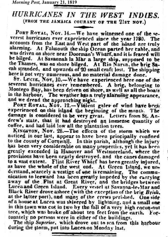
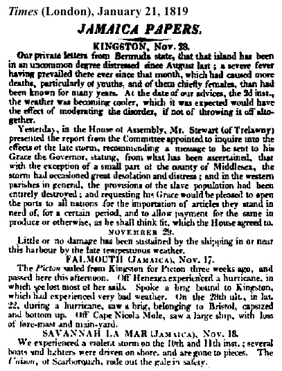
1818
October:


- but nothing specific on this storm yet, though the item below refers to 'hurricanes' apparently in October:
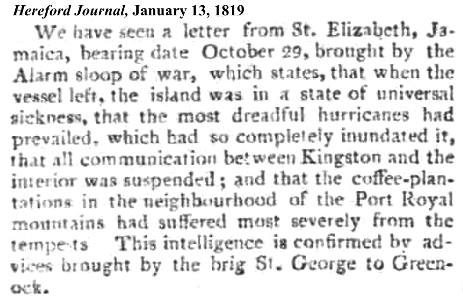
November - there appear to have been two hurricanes - one between November 8 and 12, and another between November 17 and 20:
The Journal of the Royal Geographical Society of London, Volume 25,
J. Murray, 1855
J. Murray, 1855

accounts written by Moravian missionaries:
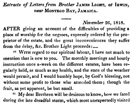
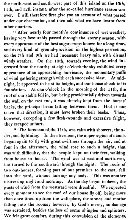
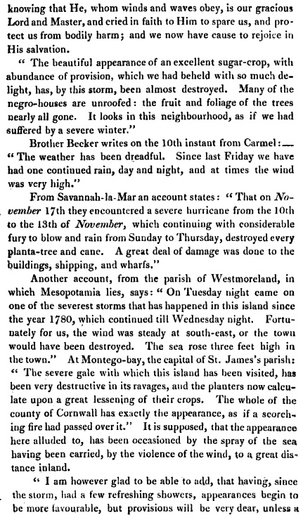
Periodical Accounts Relating to the Missions of the Church of the United Brethren Established Among the Heathen, Volume 7, Brethen's Society for the Furtherance of the Gospel, 1818
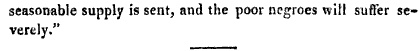
the reports reaching the UK:
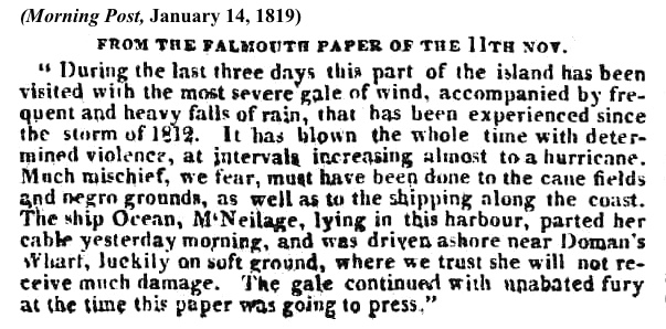

|
|
|
|
|
|
|

